
Locator One is a fully autonomous, highly accurate 3D monitoring solution designed for both geographical and structural monitoring applications. This device leverages GNSS and RADAR sensors to precisely monitor vertical ground movements and the thickness of sand layers added during construction.
In addition to measuring ground and layer settlement, Locator One is also engineered for diverse monitoring needs, including the movement of bridges, harbor quays, dam walls, and landslides, ensuring comprehensive coverage across various project types.
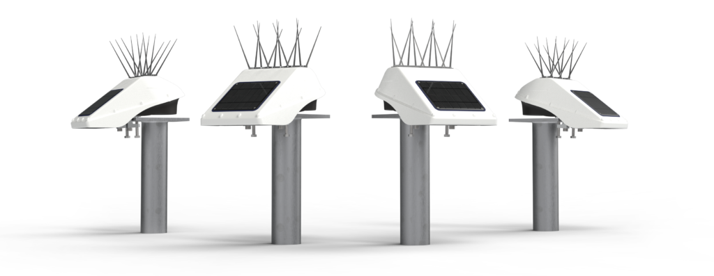
| PRODUCT INFO | Locator One |
|---|---|
| PRODUCT WEIGHT | 1547 g (excluding box and bird spikes) |
| PRODUCT DIMENSIONS | 286 x 213 x 140 mm mm (box dimensions) |
| OPERATING CONDITIONS | –40°C to +60 |
| # | TOPIC | FEATURE | TECHNICAL DETAILS |
|---|---|---|---|
| 1 | Sensors | GNSS, radar and temperature | |
| 2 | Connectivity | LTE-M (bands: B1, B2, B3, B4, B5, B8, B12, B13, B14, B18, B19, B20, B25, B26, B28, B66) | |
| 3 | Power | Supercapacitor | 4.2 V (air transport safe) |
| Capacity | 230 GNSS measurements per full charge | ||
| Solar panel | 2 W (PU solar panel) | ||
| Charging | Solar panel or USB (with custom cable) | ||
| 4 | Temperature | Inside temperature | Each measurement from –40°C to +60°C |
| Resolution | 0.1° C | ||
| 5 | Casing / material | Outside | PC-ABS white / black |
| Beam clamps | Stainless Steel A4 | ||
| 7 | Mounting | Options | Beam clamps, mounting plate and mounting bracket |
| 8 | GNSS | Constellations & bands | GPS, GLONASS, Galileo, BeiDou and QZSS L1C/A, L1OF, L2C, L2OF, B1I, B2I, E1B/C and E5b (184 channels) |
| Precision | Post Processed Static (PPS): – Horizontal Precision: 2 mm + 0.5 ppm (1σ) – Vertical Precision: 4 mm + 0.5 ppm (1σ) – Long term trend-monitoring precision: <1 mm* | ||
| Measurement frequency | 1 to 24 times per day (without external power source in Dutch weather conditions) | ||
| 9 | Radar | Operating Range | 0.40 m to 4.00 m settlement rods; 0.40 m to 7.00 m water level |
| Accuracy | 1 mm settlement rod; 10 mm water level | ||
Measurement frequency | 1 to 288 times per day depending on the application | ||
| 10 | Certificates |      |
* Based on comparing daily averages of at least 12 daily measurements under similar climatic (temperature) conditions.